
The Tokyo Marathon route, printed
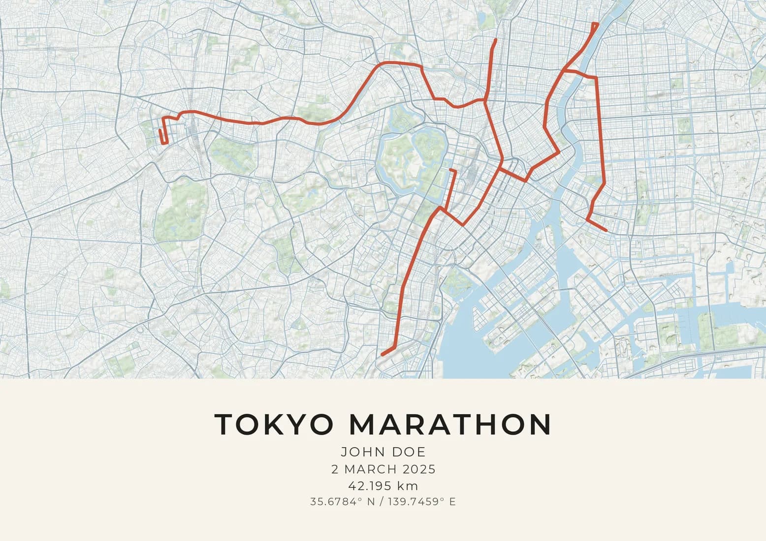
The 2025 course, 42.195 km, from Tokyo, Japan.
- Styles
- 19 colourwaysto choose from
- 300 DPIsharp at every size
- Price
- From £24.95delivered free
- Paper
- 240 gsmsmooth fine-art paper
The 2025 course is already drawn on the map, with the distance beneath it. Add your name and your finishing time, choose a style, and preview the finished artwork before you buy. Prices from £24.95, and delivery is free.
Tokyo's course was redrawn in 2017 to be flatter and faster, and it now runs from the towers of Shinjuku through the old east of the city to the wide avenue in front of Tokyo Station.
The start is beneath the twin towers of the Tokyo Metropolitan Government Building in Shinjuku, and the first few kilometres hold the only meaningful downhill of the day, a gentle drop eastwards towards Iidabashi and Suidobashi. It is an easy place to go out too fast. The route then passes Ueno-hirokoji and runs through Kanda, close to the electronics shops of Akihabara, to Nihonbashi, the bridge from which distances along Japan's national roads are measured. The shorter race held alongside the marathon finishes here.
The middle of the race belongs to the low-lying east of the city, the old shitamachi. In Asakusa the field runs past the Kaminarimon, the great lantern gate of Senso-ji temple, then turns south to Ryogoku, home of sumo's national arena, and across the Sumida River to Monzen-nakacho, around halfway. The course doubles back on itself more than once in this part of the city, so the same streets are run in both directions and runners see the leaders coming the other way. The few rises here are bridges over the river and canals rather than hills.
From Monzen-nakacho the course returns west to Ginza, then turns south as far as Tamachi before coming back north past Hibiya Park. The finish is on Gyoko-dori, the broad avenue that runs from the red-brick front of Tokyo Station towards the Imperial Palace. Until 2016 the race ended out at Tokyo Big Sight on the waterfront, after a hilly and empty final stretch that runners disliked; the new route dropped it and set out to produce records. It has: Benson Kipruto ran 2:02:16 here in 2024.
Questions
Has the Tokyo course changed since the race began?
Once in a big way. The race began in 2007 and finished at Tokyo Big Sight until 2016; from 2017 it was redrawn through Nihonbashi, Asakusa and Ginza to finish at Tokyo Station on a flatter, faster line.
Why does the Tokyo course double back so often?
Fitting the full distance into central Tokyo while taking in Asakusa, Ryogoku, Monzen-nakacho and Ginza needs several turns, so some streets are run out and back. That is also why runners pass the leaders going the other way.
Can I add my finishing time?
Yes. The title and the line beneath it are yours to write, so your name, your finishing time and your club all fit. The 2025 course and its distance are drawn for you, and you see the finished artwork before you buy.
Is this an official Tokyo Marathon print?
No. Maps & Son is not affiliated with, or endorsed by, the organisers of the Tokyo Marathon; the name says which course is mapped. The course is drawn from a route file we use with permission.
Can I change the map?
Yes. The designer opens with the course drawn and the map framed around it. Move the map if you like, choose from 19 styles, and preview the finished artwork before you buy.
How much does a race route print cost?
Prints start at £24.95, printed on 240 gsm smooth fine-art paper, with delivery included to the UK and 25 other countries. Sold as A4, A3, A2 or A1 prints, unframed, at standard sizes so a ready-made frame will fit.
Other courses
Maps & Son is not affiliated with, or endorsed by, the organisers of the Tokyo Marathon. The course is drawn from a route file we use with permission. For the race itself, see the organisers' website.